Of Nusantara and Nusantaria: Palapa and Other Names
Masa Membaca:4 Minit, 40 Saat
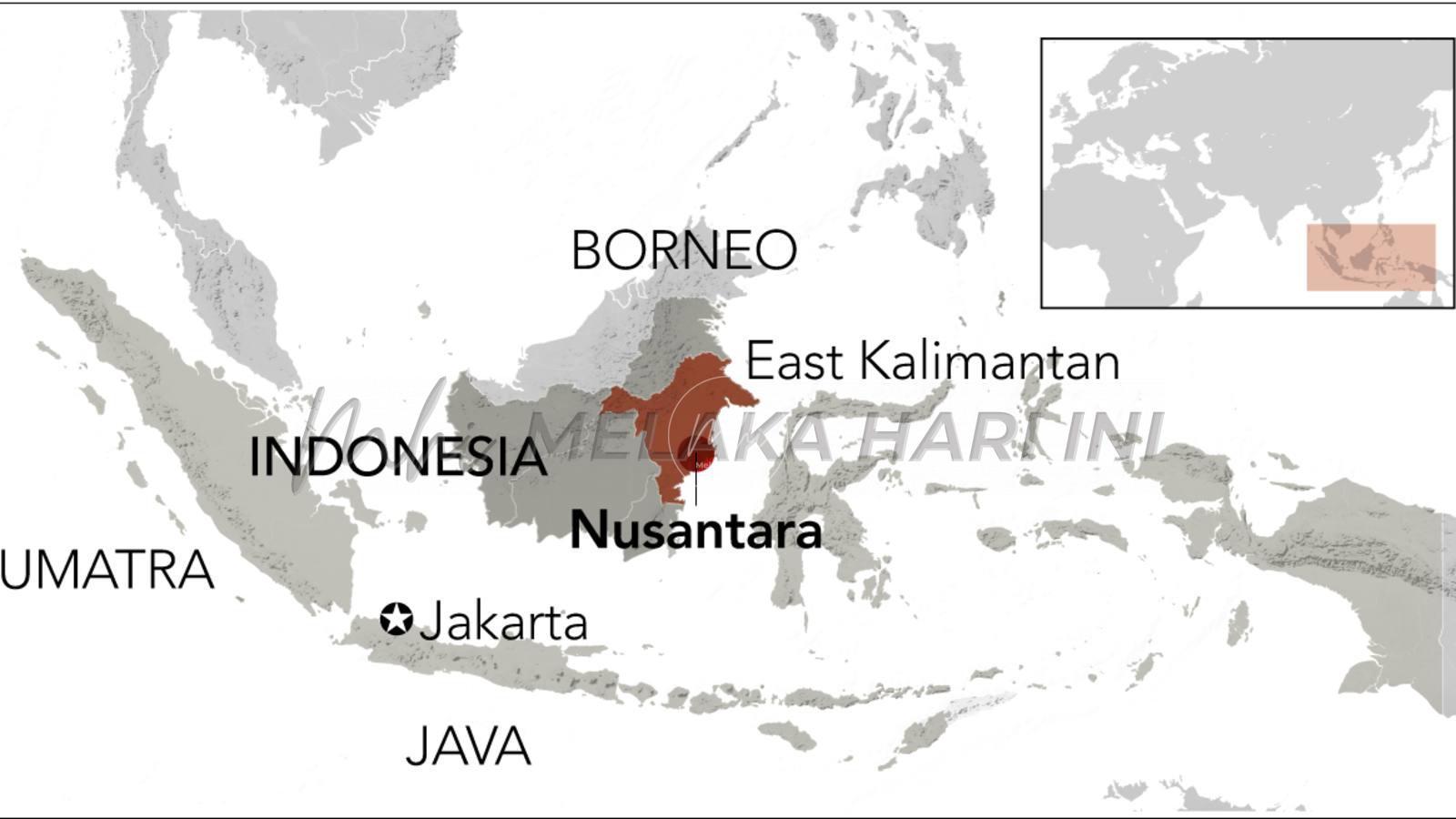
Nusantara as the new capital of Indonesia was received with mixed feelings amongst the Malay intelligentsia in Malaysia. They suggested ‘Kota Nusantara’. There is apprehension that the (Indonesian) national force of ‘Nusantara’ may eclipse the term ‘Kepulauan Melayu’ (Malay Archipelago) as a geo-cultural concept.
Jakarta gave several reasons for Nusantara. One being that the name has been known since before modern times, that ‘Nusantara’ the is internationally iconic; and that it reflects the ‘kenusantaraan’ of the Republic.
The rantau (region) is often referred to as ‘maritime South East Asia.’ A more general term ‘South East Asia’ dates only to World War II. Japan had used the term ‘Tonan Ajiya’ (South East Asia) from the late nineteenth century. In European languages it did not become widespread until the 1950s, bringing together the mainland states between China and India with the islands. It has been argued that the formation of the Association of Southeast Asian Nations (ASEAN) in 1967 added to the notion that mainland and maritime were one, in practice, they have divergent interests and religion, now as in the past.
The naming of the rantau is an interesting story. Philip Bowring in Empires of the Winds: The Global Role of Asia’s Great Archipelago (2019) traces the nomenclature over time. The ‘Indian archipelago’ or ‘Insulindia’ have long been the name of the islands. Alternatively, reference was made to the ‘Malay archipelago.’ Neither term distinguishes between the Indonesian and the Philippine island groups. These correspond roughly to ‘Nusantara’ – a name that goes back to the 13th century Java-based Majapahit empire. ‘Nusantara’ – where Nusa being a Sanskrit-derived word meaning ‘island’ and antara meaning between ‘dua benua’ (two continents). Hence literally “islands in between (two continents).” And the two continents are referred to as India, and China.
So ‘Nusantara’ is defined as the region of islands and coasts over which Majapahit rule, tribute or mercantile influence extended. According to Bowring, it covered most of what is now Indonesia, part of the Philippine Archipelago, the central Vietnam coast and the Malay peninsula: “Beyond its Javanese heart it did not rule directly but held sway over the many small mercantile states of the region.” Malays in Malaysia would use ‘Nusantara’ in the narrower sense, specifically referring to the Indonesian archipelago.
In broadening the concept, Bowring chooses the term ‘Nusantaria’ – the single maritime region between the northern entrance to the Melaka and Luzon straits, and the Banda islands in the extreme east of the archipelago. While this understanding predominantly describes the wider Malay world, and touching too on Taiwan, Madagascar and the Marianas, Nusantaria links to the coastal Thai, Chinese, Tamil and other players in the history of the exchange of goods, people and ideas. The exchange occurs from both within the region and with peoples to the west and north-east.
Nusantaria also corresponds to the term ‘Nusantao’ to define the mostly Austronesian-speaking peoples of the ancient trading networks of the islands and coasts, where tao means people in many Austronesian languages.
The maritime zone referred to is now mostly associated with its largest component, the South China Sea. Again there is the problem of nomenclature. The South China Sea is a misnomer. We have heard of ‘Nanhai’ or ‘Nanyang’ which means ‘South Sea’ or ‘Southern Ocean’ for seas that included the South China Sea, but could also refer to southern seas generally. The Vietnamese used geographical location, calling it the ‘East Sea’ because it lay to their east. And my last visit to Manila found maps sold in bookshops referring to the Philippine name on its adjacent water as the ‘West Philippine Sea’ – an obvious response to recent Chinese claims. The term ‘Philippine Sea’ had been used by early 17th century European mapmakers.
We also find Indonesia’s reference to its portion as the Natuna Sea, after the island group of that name. Its location makes many Malaysians perplexed. According to Bowring, the name ‘South China Sea’ is a European invention of relatively recent date. In the 16th century, the Portuguese , the first Europeans who got there, called it the ‘Cham Sea,’ after the mercantile state in what is now central Vietnam. And Arabs at one time called the southern part of it the ‘Malay Sea’ or the ‘Spice Sea’ because it was close to the Spice islands.
The more northern part of the ‘South China Sea’ was known as the ‘Sanf Sea’, a reference to Champa. Others call it the Luzon Sea, after the main island in the Philippines. Again it was said that Westerners refer to the portion of the area as part of the Indian Seas. ‘China Sea’ only came into Western use around 1800. ‘South’ was added in the early 20th century.
A few hundred year back, Nusantaria was almost entirely Malay – using the term ‘Malay’ in its broad cultural and linguistic sense. And what do people in the region see themselves as? They see individual entities, spheres of political influence, religion, and trade, long been linked to dynasties and rivalries, fluid interactions and interconnecting as one and many.
Recall Palapa, the series of communication satellites owned by Indonesia’s Indosat in the mid 1970s. The reason for naming the satellite ‘palapa’ resonates the past of Indonesia, in bringing together the archipelago under the ‘hegemony’ of one nation. And ‘Nusantara’ the capital? Then in the 1970s and 1980s, satellite technology was identified with media, then cultural imperialism. And perhaps too it is time to reassess notions of sovereignty among Malay nations in the region.
#####
Next week:
The Scribe’s Memoir
Langgani saluran Telegram kami untuk dapatkan berita-berita yang terkini.
Views:
7453