


Malay Peninsula and Archipelago: Revisiting Geographical data
Masa Membaca:4 Minit, 40 Saat
THE encyclopaedia gives us authoritative knowledge, a baseline data of knowing about things and objects. It can answer simple facts; and establish complex concepts. Much like the dictionary, it is a recording of what was known based on existing data at the time of publication. This week I draw attention to what has been recorded on the Malay Archipelago and the Peninsula from the Encyclopaedia Brittanica.
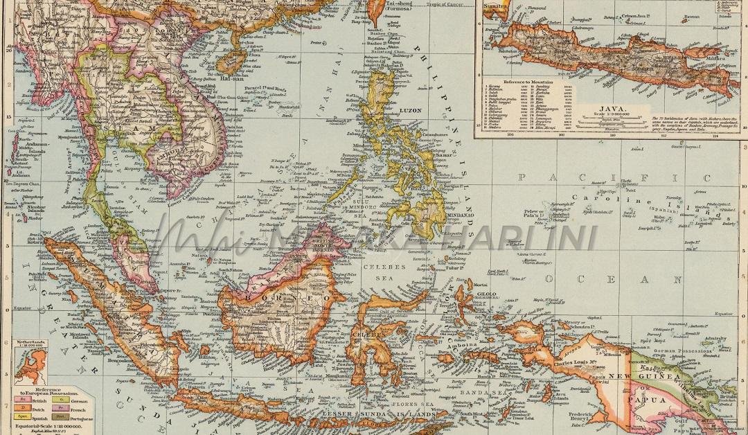
I keep a set bought more than 30 years ago. This was before the emergence of digitization and online materials; and indeed, before Google appeared into our vocabulary. New data and interpretations have been captured since then. Cognisant of the dynamics on what we know over time, the following are excerpts from its 1990 fourteenth edition. I refer to the entry “Malay Archipelago” and “Malay Peninsula” (Volume Seven, Micropaedia). The Britannica describes the Malay Archipelago as the largest group of islands in the world, comprising more than 13,000 islands of Indonesia and some 7,000 islands of the Philippines. Then it still noted that the regional name “East Indies” is sometimes used as a synonym for the archipelago.
Uncommon to many of us is the inclusion of New Guinea. It says that the island is usually arbitrarily included in the Malay Archipelago while the “Andaman and the Nicobar islands in the northwest and the Bismark Archipelago in the east are not.” The volume identifies that the principal islands and groups of Indonesia include the Greater Sundas (Sumatra, Java, Borneo, and the Celebes), the Lesser Sundas, the Moluccas, and Irian Jaya (West New Guinea). The Philippines include Luzon (north), Mindanao (south), and the Visayan islands in between.
Other political units in the archipelago are Malaysia (Sabah and Sarawak), Brunei, and arguably, Papua New Guinea. In terms of size, the total land area stated was 2,475,249 sq km. The archipelago extends along the Equator for more than 3,800 mi or 6,100 km; it is 2,200 mi. in its greatest north-south dimension. Note that the Encyclopaedia Britannica uses both the imperial and metric systems of measurement for the first time, and subsequently only the imperial system
Situated between the Pacific and Indian Oceans, the islands enclose the following seas – The Sulu, Celebes, Banda, Molucca, Sunda, Java, Flores, and Savu Seas. They are separated from mainland Asia (west) by the Strait of Malacca and the South China Sea, from Taiwan (north) by the Bashi Channel, and from Australia (south) by Torres Strait.
Structurally the archipelago divides into three parts: the Sunda Shelf, the Sahul Shelf, and the area of recent tectonic activity that lies between the two. The islands, with the exception of the northern Philippines, lie within 10 degrees of the Equator. This reminds us of high temperatures (and humidity in equatorial and tropical regions) averaging it says, at 80 degrees Fahrenheit (21 degrees Centigrade). Temperatures have shifted over the decades due to global warming. The current average diurnal would be just slightly higher. The variable climactic element is rainfall. At the time of publishing, it was recorded to range from more than 320 in (8,100 mm) annually on slopes in Sumatra and Java to less than 20 in in rain-shadow areas of western Celebes and the Lesser Sundas.
It states that most of the archipelago averages more than 80 in, well distributed throughout the year, “but the total decreases and the length of the dry season increases from central Java eastward through the Lesser Sundas and from Mindanao northward.” Common popular knowledge to us is the monsoon/musim. Most of the islands receive rainfall from both the northeast (northern winter) and the southwest monsoons.
Another climactic element is the typhoon. At that time it states of more than 20 each year in the southwestern Pacific (July to November), and then swing westward and northward, bringing violent winds and heavy rains to the Philippines. A colleague from Manila had recently joked that “we see typhoons everyday here.” The archipelago’s flora and fauna are extremely rich and varied and reflect the character of the islands as a bridge between Asia and Australia.
On the “Malay Peninsula,” the Britannica describes it as a long, narrow appendix of the mainland extending south for a distance of about 700 mi (1,127 km) through the Isthmus of Kra to Tanjung (cape) Balai, “southernmost point of the Asian continent.” This is incorrect. The southernmost point of Peninsular Malaysia and thus of mainland Eurasia is Tanjung Piai, the cape in Pontian, Johor. The district houses one of the world’s most important mangrove ecosystems.
Also called the Kra Peninsula, the Malay Peninsula lies between the Andaman Sea of the Indian Ocean and the Strait of Malacca (west), the Singapore Strait (south), and the Gulf of Thailand and the South China Sea (east). Its central mountain range, rising to 7,175 ft (2,187 m) at Gunung Tahan divides the peninsula. The west coast is exposed to the southwest monsoon, and the eastern coast to the northeast monsoons. Most of the western rivers have comparatively short courses, and navigation is limited by extensive silting near the sea. The eastern rivers are longer with flatter gradients in their upper reaches.
Politically the Britannica describes the peninsula as comprising the southwestern section of Thailand, West Malaysia and Singapore. It ends the entry with a useful note. Known in ancient times as the Chersonesus Aurea (Golden Chersonese, or Golden Peninsula, from Greek chersos, “dry” and nēsos, “island”), it has formed a physical and cultural link between the mainland and the Malay Archipelago.
Langgani saluran Telegram kami untuk dapatkan berita-berita yang terkini.
Views:
4616